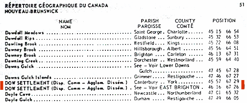
DOW SETTLEMENT, BRIGHTON PARISH,
CARLETON COUNTY, NEW BRUNSWICK
BACKGROUND and LOCATION
As indicated on the page up one
level, when those of the bbbfaa line, our direct family, who remained in
New Brunswick (many returned to the United States) left the Oromoncto/Burton areas of
Sunbury County and the Kingsclear area of York County, they moved further up the
St. John River and settled at a place that became known as Dow Settlement
(later called East Brighton and today non-existent, with the name East Brighton
designating both locations) in Brighton Parish of Carleton
County, New Brunswick.
Like the Dow Settlement in York
County, this was not a town but a specific area of farms and houses and a school
clustered together at a crossroads in Brighton Parish of
Carleton County, New Brunswick, east of the St. John River and the
town of Lower Brighton where later generations of our family lived.
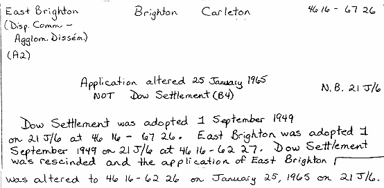
A January 12,
1965 letter [DN1262] from the Photogrammetry Branch, Department of Lands and Mines, to
the Canadian Permanent Committee on Geographical Names in Ottawa, in a paragraph
referenced B-1 and B-2 (keys also to
markings on the map below), included purported comments of a "Mr. Raymond"
and the "field staff, as the result on enquiry at the local usage and
opinion level":
"In old days
there used to be a small school in each place, but
nowadays together it is locally known and referred to as East
Brighton, - this would be better because there is another Dow
Settlement in around Canterbury, - but keep record card or file."
The
second edition (1972) of the Gazetteer of Canada for New Brunswick,
published by the the Canadian Permanent Committee on Geographical Names [DN1105], lists
both DOW SETTLEMENTS and provides their latitude and longitude ("Position -
degrees and minutes"):
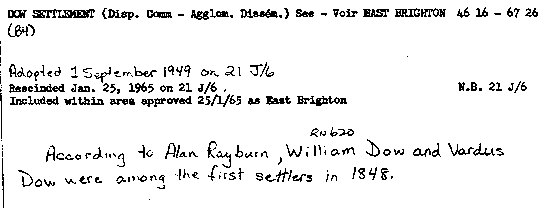
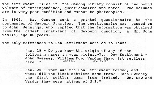
Shown below are the record cards
[DN1261] from Energy, Mines and Resources Canada. These were provided to
me in an 11 August 1988 letter [DN1260], along with the
map below and the
letter above. The letter stated that
although a "Mr. Rayburn had recently retired", the source of his information
(see second card below) was
"(Jennings 1903)". Jennings 1903 refers to correspondence from John
Jennings of Newburg Junction to W. F. Ganong, June 23, 1903, in Ganong Library,
Settlement files I, 326, New Brunswick Museum, Saint John.
[Note: the last line of the card immediately above
contains an error -"Vardus Dow" should read "Vardus Shaw" - see below]
In a 12 September 1988 letter to me from the New
Brunswick Museum in Saint John [DN1265], the following additional information
was supplied:
In summary, then, we know that Dow
Settlement in Brighton Parish of Carleton County NB was first settled by
John Sweeney (from Ireland) and William Dow [RN 620] bbbfaab, my great great
grandfather, and Vardus Shaw [RN3181] (both natives of NB) in the year 1848.
The names East Brighton (at 46 16 - 67 27) and Dow Settlement
(at 46 16 - 67 26) were adopted for map purposes by the Canadian government
on 1 September 1949. On 25 January 1965, the name Dow Settlement
was rescinded and its area included within the area approved on the same day as
East Brighton. East Brighton's location was altered to 46 16
- 62 26.
MAPS
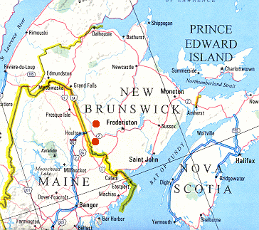
As points of reference, the red dots on the map below show the approximately
locations of both Dow Settlements in New Brunswick, the top one in
Carleton County and the bottom one in York County.
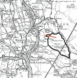
Most modern maps do not even show the name of Dow Settlement.
For example, the 1989 road map below fails to identify location by name.
The actual location is noted by the red annotation to this map.
Click on image above to
view a pdf file containing an enlargement of this map.
This pdf file is about 400KB in size, with only 1 page, but it may load slowly in some browser versions.
When viewing the pdf file in Adobe
Acrobat Reader, use the "Zoom" feature
to
increase/decrease the size of the map for easier viewing.
When done viewing the
pdf file, click on "Back" in your browser to return
here.
However, a search for older and more
detailed maps has revealed several very good maps, including the one below which
shows both the Dow Settlement of York County and the Dow Settlement of Carleton
County, co-existing at the same time approximately 25 miles from each other ("as
the crow flies").
Click on image above to
view a pdf file containing an enlargement of this map.
This pdf file is about 1MB in size, with only 1 page, but it will load slowly in
most browser versions.
When viewing the pdf file in Adobe
Acrobat Reader, use the "Zoom" feature
to
increase/decrease the size of the map for easier viewing.
When done viewing the
pdf file, click on "Back" in your browser to return
here.
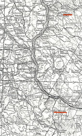
An enlarged portion of the above map, in the immediate area
of Dow Settlement in Carleton County is shown below. This map
reflects the original location of both East Brighton and Dow Settlement when
they were considered separate entities.
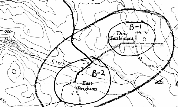
This topo map published in 1956 by
the Surveys and Mapping Branch, Department of Mines and Technical Surveys, shows
both Dow Settlement and East Brighton and the buildings associated with
each. The markings B-1 and B-2 reference a paragraph in a January 12,
1965, letter (above) :
"In old days
there used to be a small school in each place, but
nowadays together it is locally known and referred to as East
Brighton, - this would be better because there is another Dow
Settlement in around Canterbury, - but keep record card or file."
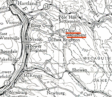
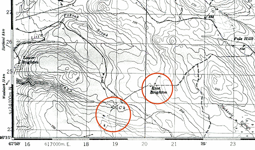
This topo map published in 1981 by
the Surveys and Mapping Branch of the Department of Energy, Mines and Resources,
based on 1976 cultural information, shows the original location of Dow
Settlement labeled as East Brighton and the original location of East Brighton
(to the south west) as unlabeled. Actually at this point in time the name
East Brighton was intended to include both areas. Note the buildings shown
on this map.
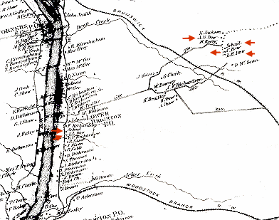
Finally, this very large format map
of Carleton County NB, published in 1876 by private subscription by Roe & Colby,
St. John NB [DN1237] (A. R. Dow,
farmer and resident of Dow Settlement was a listed subscriber). This
wonderful map not only shows all the farm houses throughout the county but also
identifies the residents. Marked by red arrows are the farm homes of:
on the St. John River - John L. Dow [RN 25] bbbfaabc, my
great grandfather, and the school (where William Taylor [RN5981] and
Marlborough Ivan Dow # [RN 18] bbbfaabca both taught)
just north of his farm, both on the St. John River; and at Dow Settlement
- Amos Robinson Dow # [RN 625] bbbfaabj, the small school
referred to above, Charles F. Dow [RN 623] bbbfaabf, and
Lothrop Hammond Dow # [RN 624] bbbfaabh.
Click on image above to
view a pdf file containing an enlargement of this map.
This pdf file is about 82KB in size, with only 1 page, but it may load slowly in
some browser versions.
When viewing the pdf file in Adobe
Acrobat Reader, use the "Zoom" feature
to
increase/decrease the size of the map for easier viewing.
When done viewing the
pdf file, click on "Back" in your browser to return
here.
LAND GRANTS
The Crown Lands Branch of the
Department of Natural Resources and Energy in a letter to me dated 16 August
1988
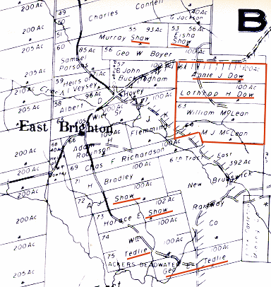
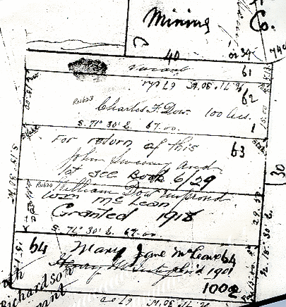
[DN1254] states that the Grant Reference Plan #102 (dated 1979) [DN1240], a portion of which is shown
below, reflects the four people that finally got the grants outlined in red in
what was part of Dow Settlement: Annie J. Dow [RN 918] (her
name was actually Ann Isabella (Shaw) Dow Hovey), second wife of Charles F.
Dow [RN 623] bbbfabf shown on an earlier plan. This grant of
#61 was received 1 September 1881 (Grant #18363 [DN 830]); Lothrop H. Dow
[RN 624] bbbfaabh, shown on an earlier plan with the name John Sweeney.
This grant of #62 was received 10 March 1879 (Grant #17527 [DN 829); William Mc
Lean, shown on an earlier plan with the name William Dow [RN 620]
bbbfaab. This grant of #63 was received 16 January 1919 (Grant
#27677); and Mary Jane Mc Lean, shown on an earlier plan with the name Henry Mc
Intyre. This grant of #64 was received 11 November 1901 (Grant #24479)
Note the family name Shaw just north
of these and to the west in what is labeled on this map as East Brighton.
These Shaw are descendants (or other relatives) of
Advardus Shaw [RN3181].
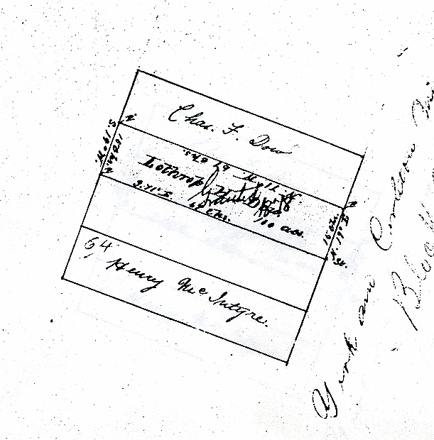
These same four lots (note lot
numbers are different than on map above) had originally been surveyed and a
"Return of Survey" Plan CN5/87 [DN1257] filed 2 May 1862 in preparation of
granting these four lots. Different names were tentatively noted on this
plan. The note "Granted 1918" on the William Mc Lean lot, was the expected
date that he was to receive his grant, but for one reason or another, he did not
receive it until 16 January 1919. The note "John Sweeny and William Dow
improved" were potential people who might receive these grants but did not.
The records show that a William Dow [RN 620] bbbfaab did petition
for a grant in 1815 (#831) when that part of Carleton County was then York
County but apparently did not receive the grant. No petition or grant was
found to John Sweeny. They were being considered at the time but the
grants never materialized. The note "for return of this lot, see Book
6/29" refers to the "Return of Survey" (1871) prior to the issuing of the grant
to Lothrop H. Dow [RN 624] bbbfaabh on 10 March 1879
below.
On the above Plan the surveyor noted
that "Almost 13 acres of C. F. Dow's lot was chopped by William Richardson many
years since but it is now partially grown up since his chop. William Mc
Lean lot is improved. Hard wood and ? growth."
Finally,
this 23 October 1871 "Return of Survey CN 6/29 prior to the issuing of the grant
to Lothrop H. Dow [RN 624] bbbfaabh, the surveyor noted "improved
by petitioner and mixed growth".