DOW SETTLEMENT, CANTERBURY PARISH,
YORK COUNTY, NEW BRUNSWICK
BACKGROUND and LOCATION
As indicated on the page up one
level, when those of the bcdg line who remained in New Brunswick (many
returned to the United States) left the Maugerville area, they moved further up
the St. John River and settled, at least initially, in the area of
Canterbury, York County, NB. This area of Canterbury was, and still is,
generally known by the name Dow Settlement. This was not a town,
per se, in the modern sense, but a specific area of farms and houses
clustered together in Canterbury Parish of
York County, New Brunswick, between the St. John River and the town of
Canterbury.
Since this was not the area that any
of our family settled in, I have done no further research about this Dow
Settlement other than the maps shown below.
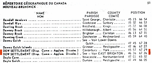
The
second edition (1972) of the Gazetteer of Canada for New Brunswick, published by
the the Canadian Permanent Committee on Geographical Names [DN1105], lists both
Dow
Settlements and provides their latitude and longitude ("Position degrees and
minutes"):
MAPS
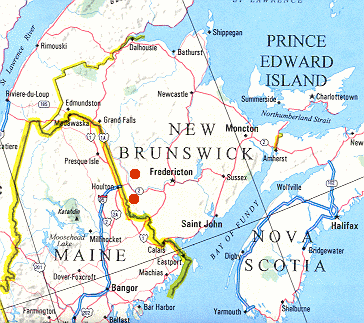
As points of reference, the red dots on the map below show
the approximately locations of both Dow Settlements in New Brunswick, the
top one in Carleton County and the bottom one in York County.
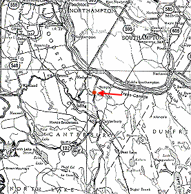
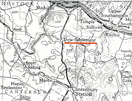
Most modern maps do not even show the name of Dow Settlement.
For example, the 1989 road map below fails to identify location by name.
The actual location is noted by the red annotation to this map.
Click on image above to
view a pdf file containing an enlargement of this map.
This pdf file is about 125KB in size, with only 1 page, but it may load slowly in some browser versions.
When viewing the pdf file in Adobe
Acrobat Reader, use the "Zoom" feature
to
increase/decrease the size of the map for easier viewing.
When done viewing the
pdf file, click on "Back" in your browser to return
here.
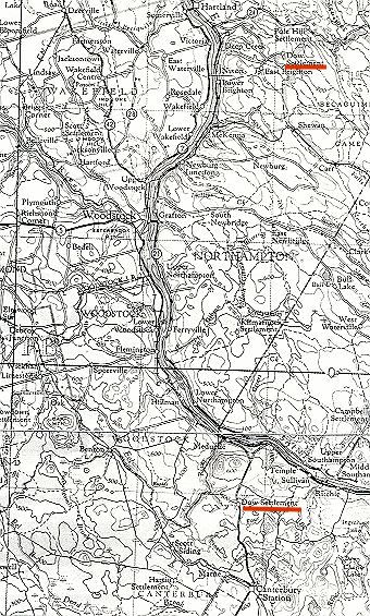
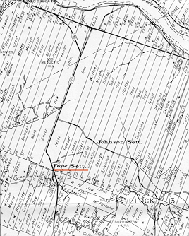
However, a search for older and more
detailed maps has revealed this very good map which shows both the Dow
Settlement of York County and the Dow Settlement of Carleton County, co-existing
at the same time approximately 25 miles from each other ("as the crow flies").
Click on image above to
view a pdf file containing an enlargement of this map.
This pdf file is about 1MB in size, with only 1 page, but it will load slowly in
most browser versions.
When viewing the pdf file in Adobe
Acrobat Reader, use the "Zoom" feature
to
increase/decrease the size of the map for easier viewing.
When done viewing the
pdf file, click on "Back" in your browser to return
here.
An enlarged portion of the above map, in the immediate area
of Dow Settlement in York County is shown below.
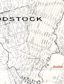
LAND GRANTS
The Crown
Lands Branch of the Department of Natural Resources and Energy maintains maps
reflecting the names of the original grantees. These are updated over time to
reflect the transfer of ownership. Two such maps are shown below.
Grant Reference Plan #124 (dated 1979)
[DN1248], a portion of which is shown below, shows the grants around Dow
Settlement in York County. This area is to the east of that shown on
the second map below. Note that the long, narrow parcels near the top of
the map extend all the way from Dow Settlement northward to the bank of the St.
John River.
Click on image above to
view a pdf file containing an enlargement of this map.
This pdf file is about 270KB in size, with only 1 page, but it may load slowly in some browser versions.
When viewing the pdf file in Adobe
Acrobat Reader, use the "Zoom" feature
to
increase/decrease the size of the map for easier viewing.
When done viewing the
pdf file, click on "Back" in your browser to return
here.
Grant Reference Plan #123 (dated 1979)
[DN1247], a portion of which is shown below, also shows the grants around Dow
Settlement in York County. This area is to the west of that shown on
the first map above. Note that the long, narrow parcels near the top of
the map extend all the way from Dow Settlement northward to the bank of the St.
John River.
Click on image above to
view a pdf file containing an enlargement of this map.
This pdf file is about 700KB in size, with only 1 page, but it may load slowly in some browser versions.
When viewing the pdf file in Adobe
Acrobat Reader, use the "Zoom" feature
to
increase/decrease the size of the map for easier viewing.
When done viewing the
pdf file, click on "Back" in your browser to return
here.